Forum/General Discussion/Looking at maps

Looking at maps

478 views·5 replies·by BoatGuy
BoatGuy
BoatGuyFREEJan 26#1
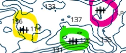
Trying to find new spots by looking at maps.

Are the objects circled wrecks?
1769436006468.webp
First MateOriginal Crew780 postsSince 2019
MakoMatt
MakoMattMODJan 26#2
Maps are used for land. CHARTS are used for water.
Yes, they are the symbols on a CHART of a shipwreck.
What area is that chart showing?


CaptainOriginal Crew2,076 postsSince 2018
pequa1
pequa1MODJan 26#3
Trying to find new spots by looking at maps.

Are the objects circled wrecks?

View attachment 111120
what sort of boating safety course did you take ? The USCGA course I took in 1975 covered this, anchoring techniques, knot tying, navigation and more. It was at an adult education setting in a high school and was 8 or 10 Tuesday nights IIRC. The Nassau County Police course I took in 2007 or so was a waste of two days but gave us a shiny plastic card, lol. It was geared towards jet ski shit. Somewhere in between was an online USCG course.
CommodoreOriginal Crew7,027 postsSince 2018
BoatGuy
BoatGuyFREEJan 26#4
I took a Power Squadron Course (and passed). I took the BoatUs course as a refresher. I was 99% sure.
Just checking.
First MateOriginal Crew780 postsSince 2019
MakoMatt
MakoMattMODJan 26#5
I took a Power Squadron Course (and passed). I took the BoatUs course as a refresher. I was 99% sure.
Just checking.
BoatGuy, no problem, good luck on the wrecks!!!
CaptainOriginal Crew2,076 postsSince 2018
BoatGuy
BoatGuyFREEJan 26#6
Just looking for new places to try....bored with all the snow.
First MateOriginal Crew780 postsSince 2019

Sign in to reply to this thread.