It went west of here.
The cold and the wind is the big stories


It went west of here.
The cold and the wind is the big stories

Sometimes, it ain't Pretty In Pink!! We'll see your storm winds and raise you to close to hurricane force wind gusts peaking during Friday's high tide, the highest one of the month. Entire coast has a Coastal Flood Watch and 20' waves!!! To add insult to injury, ALL RAIN, no snow!!! :mad::mad::mad::mad::mad:
Too bad it will be raining sideways, always like to head down and see the huge waves. I'll be battening down the hatches today and test the generator...
Holy Cr-p!!! We are neber gonna catch herring,sheesh
Severe thunderstorms are possible ahead of the vortex on Friday.
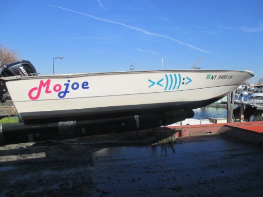
Funny part is mojoe knew that already but felt the need to ask again I wonder why
general i forgot :p:LOL:;),,,,,,,,,,,,just being funny?,,,,,,,,,,,,,,,,[COLOR=rgb(26, 188, 156)] ><)))):>
<))):>[/COLOR]
Wind advisory for the entire tri state area. Coastal flood warning for all South facing shores. 10pm Thursday to 10pm Friday. Winds gusts 55 to 60 mph. A high wind warning might be needed. Coastal flooding at times of high tide for all coastal communities
Life threatening blizzard 22nd thru the 24th is possible. Will do 2 updates a day
Let’s do this ….keep it comin!
It went west of here.
The cold and the wind is the big stories
For PropJohn and herring, cold, snow, moon tides and rain , no biggie. BUT, I never had much luck with herring with honking winds. Even less if they are Easterly. Hey, New Years herring works for me.
For PropJohn and herring, cold, snow, moon tides and rain , no biggie. BUT, I never had much luck with herring with honking winds. Even less if they are Easterly. Hey, New Years herring works for me.
For Reynolds Channel
Overnight
E winds around 5 kt, increasing to 5 to 10 kt late. Waves 1 ft or less.
Thu
E winds 10 to 15 kt, increasing to 15 to 20 kt in the afternoon. Waves 1 ft or less, then 2 to 3 ft in the afternoon. Rain in the afternoon.
Thu Night
E winds 20 to 25 kt with gusts up to 35 kt, becoming SE 25 to 30 kt with gusts up to 45 kt after midnight. Waves 2 to 3 ft. Rain. Vsby 1 to 3 nm.
Fri
S winds 25 to 30 kt, becoming SW in the afternoon. Gusts up to 45 kt. Waves 2 to 3 ft. Rain and slight chance of tstms in the morning, then chance of showers, slight chance of tstms and snow showers in the afternoon. Vsby 1 to 3 nm.
Fri Night
W winds 25 to 30 kt with gusts up to 40 kt. Waves 2 to 3 ft.
Sat
W winds 20 to 25 kt with gusts up to 30 kt. Waves 1 to 2 ft.
Sat Night
W winds 15 to 20 kt with gusts up to 30 kt. Waves 1 to 2 ft.
Sun
W winds 15 to 20 kt with gusts up to 25 kt. Waves 1 to 2 ft.
36 going up to 54 by 2am tomorrow morning then temps steady or slowly falling. Rain starting around 11am this morning and continuing into tomorrow morning.

Today
Rain, mainly after 4pm. High near 52. East wind 5 to 15 mph, with gusts as high as 25 mph. Chance of precipitation is 90%. New precipitation amounts between a tenth and quarter of an inch possible.
Tonight
Rain, with thunderstorms also possible after 1am. Temperature rising to around 52 by 4am. Windy, with an east wind 21 to 29 mph, with gusts as high as 50 mph. Chance of precipitation is 100%. New rainfall amounts between 1 and 2 inches possible.
Friday
Rain showers before 4pm, then a slight chance of snow showers. Some thunder is also possible. Temperature falling to around 28 by 5pm. Wind chill values between 10 and 20. Windy, with a south wind 24 to 31 mph, with gusts as high as 55 mph. Chance of precipitation is 90%. Little or no snow accumulation expected.
Friday Night
A 20 percent chance of snow showers before 1am. Mostly cloudy, with a low around 13. Wind chill values between -5 and 5. Windy, with a west wind 24 to 28 mph, with gusts as high as 43 mph.
Saturday
Partly sunny, with a high near 24. Breezy, with a west wind 18 to 24 mph.
Saturday Night
Partly cloudy, with a low around 13.
Christmas Day
Sunny, with a high near 28.
Today
Rain, mainly after 4pm. High near 52. East wind 5 to 15 mph, with gusts as high as 25 mph. Chance of precipitation is 90%. New precipitation amounts between a tenth and quarter of an inch possible.
Tonight
Rain, with thunderstorms also possible after 1am. Temperature rising to around 52 by 4am. Windy, with an east wind 21 to 29 mph, with gusts as high as 50 mph. Chance of precipitation is 100%. New rainfall amounts between 1 and 2 inches possible.
Friday
Rain showers before 4pm, then a slight chance of snow showers. Some thunder is also possible. Temperature falling to around 28 by 5pm. Wind chill values between 10 and 20. Windy, with a south wind 24 to 31 mph, with gusts as high as 55 mph. Chance of precipitation is 90%. Little or no snow accumulation expected.
Friday Night
A 20 percent chance of snow showers before 1am. Mostly cloudy, with a low around 13. Wind chill values between -5 and 5. Windy, with a west wind 24 to 28 mph, with gusts as high as 43 mph.
Saturday
Partly sunny, with a high near 24. Breezy, with a west wind 18 to 24 mph.
Saturday Night
Partly cloudy, with a low around 13.
Christmas Day
Sunny, with a high near 28.
spot on general 8-)(y),,,,,,,,,,,,,,,,,,,,,,,,[COLOR=rgb(26, 188, 156)] ><)))):>
<)))):>[/COLOR]

Holy Crap!!!!
[URL unfurl="true"]https://kdvr.com/weather/wx-news/denver-airport-sees-record-breaking-temperature-drop/[/URL]
DENVER (KDVR) — An arctic cold front arrived in Colorado on Wednesday afternoon, bringing strong wind and an extreme temperature drop that will stick around until the weekend.
The temperature change was drastic. Wednesday’s high in the metro reached a pleasant 50 degrees at the National Weather Service monitoring station at Denver International Airport.
[HEADING=1]Record-breaking temperature drop[/HEADING]
But as the front moved in, bringing strong wind and blowing dust, the temperature plummeted — and fast. NWS recorded a temperature of 42 degrees at 3:53 p.m. Within an hour, the temperature had dropped to 5 degrees.
The [NWS said the data is preliminary]('https://twitter.com/NWSBoulder/status/1605728289913544706'), but that is the biggest one-hour temperature drop in the airport weather station’s history.
Sign in to reply to this thread.